_______________________________________________________________________________________________________________________________________
Copyright © 2013 Ughtasar Rock Art Project Team. All rights reserved. V6 Jan 2016
Methodology: The methodology developed for recording the petroglyphs at Ughtasar is based on ‘rapid survey’, with follow-up ‘specialist photography’ and ‘GPS/topographical survey’. These techniques are applied to all of the carved rocks, including those marked with modern ‘graffiti’, in order to achieve the key objective of a total quantitative survey of the rock art within the study area. The techniques have been chosen and progressively refined in order to cope with the demands of working within a tight budget at high altitude in a remote, challenging and often harsh environment.
For purposes of initial search and recording the boulder streams containing the major concentrations of rock art are divided into 50m x 50m grid squares, each of which is then searched and recorded in as systematic a manner as possible. In the areas of more-or-less open grassland disciplined field-walking survey within ad hoc ‘control-grids’ is used to find and then record the petroglyphs. In addition to documenting the rock art, the survey includes the GPS mapping of topographical and archaeological features and the limited collection of surface finds, including obsidian artefacts and pottery sherds.
All data is entered into an Excel spread-sheet acting as a database, with procedures in Visual Basic to allow searching and comprehensive data retrieval. Rock locations and other data are plotted on a GeoEye satellite photograph background. The database cross references to the photographs and provides instant display for a selected rock. The Excel format provides an easy method of data sharing throughout the team.
Rapid survey: Rapid survey is carried out by teams of two or three fieldworkers who first search for and then record each rock upon which petroglyphs can be seen. A GPS reading and three or four basic digital photographs are taken and the characteristics of the rock, its immediate surroundings and the petroglyphs upon it are noted (and sketched) on a pre-printed paper record form. This is later duplicated for back-up purposes and key aspects of the written record are transferred to the project’s Excel database. 
GPS/topographical survey: More accurate GPS positions for each rock are also collected, using higher-grade equipment and a minimum of 300 satellite readings (achieved at each rock in about 5 minutes). For various reasons it proved impractical to implement differential GPS but the accuracy and consistency achieved within the adopted method has proved sufficient for re-locating rocks and for comparing distribution patterns across the study area. Stone-built enclosures and other archaeological or natural features are also recorded as points or tracks for incorporation in the project’s general mapping work.
Specialist photography: As a second stage in the recording each rock and its immediate surroundings is subsequently photographed more fully using higher-grade equipment, carefully chosen camera angles and (when and where possible) lighting that will show the petroglyphs to best advantage. This may involve one or more episodes of photography and the collection of a substantial number of images for the more complex rocks. A circular polarising filter is used on occasions to emphasise the contrast between the shiny rock surface and the more roughly textured petroglyphs.
Advanced imaging techniques: Members of the Ughtasar team are testing and refining innovative (non-contact) techniques for the enhanced recording and visualisation of selected rock art panels, particularly those where the petroglyphs are difficult to see in normal lighting conditions and those which are in danger of deterioration through further flaking of the rock surfaces. The methods need to be robust, flexible and adaptable to cope with the rugged terrain and demanding weather conditions.
One of the Project’s objectives is the training, transfer and sharing of skills in rock art recording, in this case involving the image-capture and subsequent processing and visualisation of 3D digital data acquired without any potentially-damaging contact with the rock art panels themselves. It is hoped that the work at Ughtasar will help to establish effective, affordable and transferrable digital techniques which can be used in the future by colleagues and students at other rock art sites in Armenia and elsewhere.
The three specialist techniques chosen for experimental application at Ughtasar are ‘stereo photogrammetry’, ‘multi-image photogrammetry’ and ‘multi-light imaging’, each of which is described briefly below.
In refining and applying these techniques the Project has received invaluable guidance and encouragement from Paul Bryan, Geospatial Imaging Manager at English Heritage and Dominic Powlesland of the Landscape Research Centre; also Jon Bedford, Senior Technical Survey and Graphics Officer , English Heritage; specialists Richard Stroud and Steve Tovey, and multi-light imaging specialist Sarah Duffy.
 Stereo photogrammetry ; Stereo photogrammetry is an effective method for creating and viewing images in 3D from stereo pairs of digital photographs taken from slightly different positions. The photographs are subsequently processed by computer software to produce a much more accurate
 model of the subject than can be achieved by conventional 2D photography. The topography of the rock, the surface texture and the relative depth of the carving can be rendered with mathematical precision providing detailed information for subsequent analysis and dissemination.
At Ughtasar the procedures for capturing the stereo images have been specially adapted to cope with the very bright sunlight and strong winds that often prevail. These, together with the rocky terrain, make the otherwise-standard use of tripods and artificial shading impractical within the study area. Following experimental trials, it was discovered that the use of hand held cameras to capture the stereo pairs of photographs in direct sunlight resulted in the creation of models with improved contrast between the carved and non-carved surfaces, making the pecked motifs much easier to observe, particularly in the overlain texture files.
Multi-image photogrammetry: Multi-image photogrammetry (or ‘Structure from Motion’ ) has several advantages over traditional stereo photogrammetry including the fairly rapid and flexible capture of the images, a reduced requirement for calibrated photographic equipment, relatively affordable software and the ability to use the same images in a variety of other modelling and visualisation applications such as Autodesk 123D Catch and Microsoft Photosynth.
Team members Ken Saito and Chris Musson are leading the work in multi-image capture with subsequent Agisoft PhotoScan processing in order to construct textured 3D models of some of the most complex, interesting and endangered carved rocks in the study area.
Results from trials in 2012 -2014 suggest that this rapidly developing technique will prove invaluable for on-site recording at Ughtasar and elsewhere. The method will allow the subsequent examination off-site of severely damaged petroglyphs, enable the creation of accurate 3D and 2D drawings of carved panels without any contact with the rock surface, and will hopefully enhance the visibility of fine detail including individual peck-marks and subtle changes in the rock surface such as natural cracks etc. The technique is also being refined for the re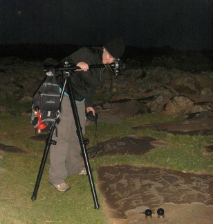 cording and visualisation of the stone-built enclosures and other natural or man-made structures within the study area.
Multi-light imaging: This technique is also known, in a variety of forms, as Highlight-Reflectance Transformation Imaging (H-RTI), Reflectance Transformation Imaging (RTI) and Polynomial Texture Mapping (PTM).
In contrast to the previous two technique (in which the camera moves position between shots) this is a ‘multi-lighting’ technique in which successive digital photographs are taken with the camera in a single position while an artificial light source is aimed from different positions at the surface of the object, cumulatively creating a virtual ‘dome’ of light. The resulting photographs are processed with computer software to produce a ‘virtual’ model
onto which a digital light-source can be shone from any direction so as to reveal subtle surface topography and textures which may be almost invisible under normal lighting conditions (Duffy, 2013). The method is unsurpassed so far for capturing fine surface detail. The technique provides a low-cost means of acquiring the images for subsequent processing even under the demanding conditions encountered during fieldwork in 2010 and 2011. The best results are obtained by photographing after sunset, which presents a number of challenges at Ughtasar, including precarious rock-streams, low temperatures, strong winds and the possibility of prowling bears or wolves. However a number of successful models have been created and it is planned to increase the use of the technique in future fieldwork seasons.
References & further reading:
Bowden, M. 1999. Unravelling the Landscape. An Inquisitive approach to Archaeology. Stroud: Tempus (English).
Bradley, R. 1997. Rock-art and the Prehistory of Atlantic Europe: Signing the Land. London:Routledge (English).
Bryan, P. Photogrammetry as a Field Recording Tool: http://archaeologydataservice.ac.uk/catalogue/adsdata/
arch-836-1/dissemination/pdf/ERA_PG1_Photogrammetry_Field_Work.pdf
Duffy, S. 2013. Multi-light Imaging for Heritage Applications. English Heritage Publishing http://www.english-heritage.org.uk/publications/multi-light-imaging-heritage-applications/Multi-light_Imaging_FINAL_low-res.pdf
Sharpe, K., Barnett, T. & Rushton, S. 2008. England’s Rock Art. The Prehistoric Rock Art of England: Recording, managing and enjoying our carved heritage. English Heritage and Northumberland County Council. http://archaeologydataservice.ac.uk/catalogue/adsdata/arch-836-1/dissemination/pdf/ERA_Brochure.pdf
Sharpe, K. & Barnett, T. 2008. Recording England’s Rock Art: A Handbook for Project Officers. Archaeology Data Service. http://archaeologydataservice.ac.uk/catalogue/adsdata/arch-836-1/dissemination/pdf/ERA_Recording_Handbook.pdf
Whitley, D.S. (ed.) 2001. Handbook of Rock Art Research. Walnut Creek, California: AltaMira Press
Whitley, D.S. 2011. Introduction to Rock Art Research. California: Left Coast Press

Ughtasar Rock Art Project